Blog
A Guide to Kayaking From Panama to Colombia, a.k.a the Darien Gap
Want inspiration or something information about crossing Panama to Colombia by kayak? Check this out.
Table of Contents
Introduction
Route summary
Preparation
Where to get ready
Where to stay in Panama City
Visa
Health
Equipment
Transportation
How to ship your bike (bicycle touring specific)
Navigation
Route Information
Overall route
Day to day travel
Navigation
Safety
Culture
Wildlife
Accommodation and camping
Equipment
Food
Budget
Overall tips
Conclusions

Introduction
In October 2023, I set out to kayak from Panama to Colombia, solo. This area follows the "infamous" area known as the Darien Gap.
Beautiful coastlines, daily thunderstorms, amazing people and islands filled with coconuts.
Below, is a guide for people who are want to attempt something similar or are just interested! Please enjoy.
*Looking for my video, link here: https://youtu.be/RUZAT1BNuZ4?si=TsddDxxcjlyiCug1
Route summary
I left from Lago Gatun, kayaking through the lake portion of the Panama Canal to the ocean facing side. A portage over to Rio Chagres, followed out to the ocean. Passing by Colon, Portobelo, to the Gulf of Guna Yala.
From there I passed through the San Blas Islands heading into the area known as the Darien Gap. I continued along, reaching the final port in Panama, Puerto Obaldia. From there a short distance to Capurgana, Colombia where my kayaking journey ended.
Preparation
Where to get ready:
I got ready for my journey in Panama City, which I would recommend. For a few reasons:
Ability to buy new and used kayaks
All other equipment can be found relatively easily
Lots of options for places to stay
Where to stay in Panama City
I stayed at the Overland Embassy, a business which specializes in shipping Overlanders from Panama to Colombia.
They also have a campground available, which was easy to plan my trip from. But, my main reason was I was travelling by bicycle (https://www.keiferaedelmayer.com/blog/what-am-i-doing-cycling-around-the-world) and looking to ship my bicycle to Colombia.

Other options you could try for accommodation during your preparation:
Warmshowers (for cyclists)
Trustroots, Couchsurfing, other accomodation apps
A hostel (next budget friendly option)
Notes:
Be ready for preparation to take at least a week
I took 13 days in total in Panama City
Visa requirements:
You will need to have ability to enter both Panama and Colombia. Your exit stamp location for Panama is Puerto Oblida. A coast town accessible only by boat. The entrance stamp for Colombia is in another coastal town called Capurgana, about 15 km following the coast from Puerto Oblida.

Notes:
I was easily able to get my exit and entrance without any fees.
Get your exit stamp in the morning, not the night before
Health:
Malaria: Both Panama and Colombia have marked the areas with the possibility that Malaria transmission can occur. A Malaria medication should be considered. At the bare minimum, proper insect repellent and clothing is necessary.
Insurance: Make sure your covered for what could be deemed a extreme activity. The region may limit this, check with insurance providers.
Medication: Carry all needed medication with you, Malaria medication, ibuprofen, etc, whatever is needed
Sun: Expect heavy sun all day and high heat during kayaking. Dehydration and heavy sunburns are real dangers. I recommend kayaking with the bare minimum amount of exposed skin, with sunscreen always on. Taking a electrolyte salt mix would be a good call
Insects: While mosquitos are present. The sand flies are terrible, some are small enough to fit through your tent mesh and bite all night. I recommend bringing a full set of light weight (remember the heat) set of clothes to sleep in and cover your body when in and around camp.
Notes:
Bring an anti-chafe, vaseline for example. This is one medical item I really wish I had
Light pants, long sleeve top, socks, and a face bug net for sleeping and wandering around camp for the sand flies
Equipment:
Sourcing a kayak can be difficult in Panama City. There are really three options:
Option 1: Panama Paddle Center, Diego
Diego owns the one serious kayak store in town, I do recommend checking it out and talking to him at the very least. He has a lot of information about the area. This will be the most expensive option just because 90% of your options will be new

Option 2: Used markets, aka FB marketplace
If the used market has any kayaks you can potentially purchase them. When I was there, this wasn't a option. My friends where able to find some when they did the crossing. Cheaper, but very dependent on what is available on the current market.
Option 3: A cheap sporting goods store
You can probably find a cheap kayak at a department store meant for recreation use. But I honestly wouldn't recommend this. Having your boat fail would be a huge, potentially life threatening problem. Cost wise this would probably be between option 1 and 2, same for difficulty acquiring.
Closed or Open Kayak
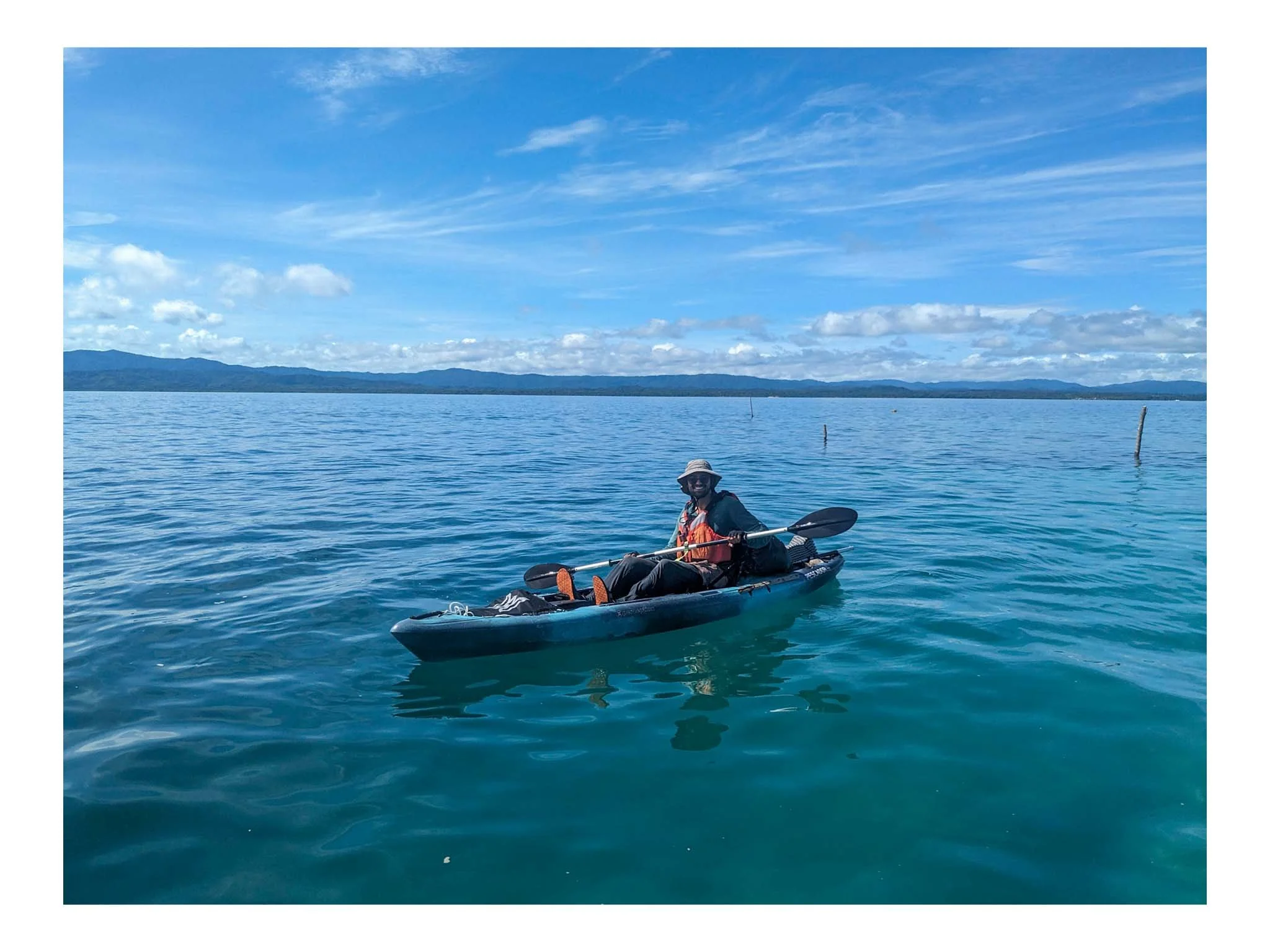
Simply, can you roll a kayak? If you don't know what that means or can't, a open faced kayak is what you should be using. Touring kayaks are closed shell, which can make your life easier, but not necessary. The kayak I used was a Pescador Pro 12 open face kayak.
Other Equipment
I would again suggest Diego's shop for kayak related gear like paddles, PFD, etc.
For things I couldn't find there, like a marine radio, I found at Abernathy (Marine store). One could also try a outdoor sporting store for other simpler items like sunhat l, sunglasses, etc for example.
Notes:
I purchased my kayak at Diego's shop, along with PFD, a paddle and a spare, leash, and some bags for wallet/passport
At Abernathy I bought a marine radio, rope, sunhat, and sunglasses. The rest of my gear was taken from the cycling equipment I was already carrying
Transportation:
Where to start your kayaking is a bit overwhelming, here are three options. The first two are very concrete with a third giving some wiggle room.
Option 1 (what I did): Start in Lago Gatun
Pros:
Close to Panama City
Taxi and rides cheap
Cons:
Police
Large boats
May not be possible
You can start at the boat launch here in Lago Gatun. It takes 2-3 days to cross the lake. The difficulty comes with the police patrolling the lake. At the time I was allowed to be there, this may have changed. Either way expect being stopped a lot or denied entry.
Also you need to be aware and stay out of the shipping lanes. Then expect a portage at the end with no good spot to land and about a half kilometre walk to the river boat launch.
Notes
Another option would be start at the boat launch at Rio Chagres, bypassing the lake.
Option 2 (what my friend Silvan did): Start at Puerto Carti in the San Blas Islands
Pros:
Shorter time to Colombia
Right into the more remote area
Cons:
Taxi up is very difficult. The entering the area around Carti requires a special pass for taxis. You may have to go half way, and then get a ride from a local who can take you the rest of the way
Costs a lot more to ride all the way up there, around a 100 USD
You cannot leave directly from Carti by kayak, you have to be towed by a motor boat to another island (more money to pay a fishing boat to take you)
Option 3 (Portobelo or the surrounding area):
Pros:
Avoid the cops and Colon (I have been warned about the area around Colon being dangerous)
Small towns, more relaxed leaving
Cons:
Taxi up, could cost a decent chunk
You have to research more places to launch, businesses, boat launches, harbours, etc
The third option is Portobelo and all the small towns, marinas, and businesses you could leave from. You would have to research the area more though, and find a ride up. But it could be cheaper than option 2 and a full ride could probably be possible.
How to ship your bike (for bike packers and cycle tourists)
I would say there are four options.
Option 1: ship your bike with a Overlander (what I did)
Pros:
Your bike will probably arrive ahead of you in Colombia
Can be the cheapest option
You don't have to take it with you
Cons:
You have to find someone willing to take your bike, this can take some time
Cartagena is your only option
You have to find someone to watch your bike if you arrive after
The Panama Overland Embassy is a business which specializes in shipping vehicles from Panama to Colombia.
I was able to camp there and talk to people shipping their vehicle. One couple let me put my bike inside and dropped it off at a Warmshowers house who agreed to watch it.
If you go this route, Alihandro is the owner of Panama Overland Embassy and is very helpful.
Option 2: Take your bicycle with you
Pros:
Your bike is with you, no need for other transport costs
Cons:
Will need a larger boat, 2 person kayak to fit it on top
Need to wrap your bike with plastic wrap heavily. Salt water destroys everything
If anything happens to you on the water, flipping, waves, etc, you could lose your bike
I had a friend do this, but after doing the crossing myself I would not recommend. You would need to find a larger boat and if anything happens you could lose your bike.
Option 3: find somewhere to leave it, and fly a round trip.
Pros:
Only have to find somewhere to store
Flights between Panama city and Medellin/Bogota are pretty cheap
Can be done completely on your time
Cons:
Flying with a bike costs more and is a hassle
You have to backtrack
Another idea I had was find somewhere to store my bike in Panama City. After finishing kayaking, book a return flight somewhere in Colombia to Panama City. Pick up the bike, and fly back. While this would be a pain, it could be a solution if you can't find anything else/help.
Option 4: Find a sailboat or boat crossing which can transport your bike
Pros:
Don't have to take your bike
Can schedule ahead of time
Cons:
Could cost a decent amount
Have to be there to pick up your bike
I have heard this was an option in the past. I have no idea if this service is still available or if you could find a individual to do this. You would need to research on your own.
Navigation
For safety and navigation I had three devices. My phone, a Garmin inReach Mini 2, and my marine radio.
Phone: Used for navigation, a mix of Google maps and satellite view to find campsites, mark distance, view hazards, etc. When I had service I could also check weather, stay in touch, etc.
Garmin inReach: Used to ping my camping location to my family to track. It also has a SOS button for very extreme emergencies. Also had a electronic compass.
Marine radio: Had a smaller range of about 50 km. Which could be used in emergency to check for immediate help. This was just backup, I did not use this the whole trip. Another electronic compass was in the device.
Notes:
Switch google maps to satellite to preload the images
Finding pictures of the coastline or taking screenshots of satellite images would be useful in advance
I had no cell coverage past the San Blas, with Claro. There were towers, so I imagine another provider has coverage. Research into this would be beneficial
Route Information
What to expect
Prepare for 20 to 30 km of kayaking daily and 5-8 hours on the water actively paddling. Most camp spots I scouted the night before on Google maps. I had no service past the San Blas Islands.

My route
Lago Gatun: lots of cops and stopping to check passport, gators present, take caution
River Chagres: gators, take caution
River to Portobelo: towns along the way, have to pass Colon
Portobelo to Gulf of Guna Yala: more remote, later part not a lot of camp spots
San Blas Islands: easy to camp, may have to pay on islands
Area pass main grouping of islands and into Darien Gap area to Puerto Obaldia/Capurgana: camping is okay, similar to the area before the islands
Notes
21 days in total, I would recommend a break. I did it without and it was challenging
Weather dependent, if you have bad storms, you have to get off the water
I was told that mid December is not possible, better to be done by December. Other sources online said Oct/Nov was bad, but it was doable.
My recommendation of being done by mid December was from Diego
Day to day travel
For a recap of my day to day, check out this article here (https://www.keiferaedelmayer.com/blog/kayaking-panama-to-colombia-along-the-darien-gap-a-day-to-day-journal)
Navigation
My method of navigation was using a mix of Google maps, OSM, and sight.
As stated above, I had service till the San Blas Islands and then none till Capurgana. I was using Claro. Plan accordingly or find another provider.
Each night I would plan out my route, using the measuring tool for Google maps and map out about 20-25 km of travel. I would look for coastline and islands in the area I could potentially camp safely. During the day I would check the route on Google maps.
I didn't take paper maps with me, but if you were to take them they would need to be waterproof (lots of surf, rain, chances to get wet)
I carried no maps of local reefs/marine maps. All reef navigation was done by eye. Again weather was by eye, with no service for half the trip, this was my only option.
Navigating safely
To navigate safely, specific things to watch for:
Surf on beach and entering/leaving shore: With tides, waves can be smaller and larger at times. Watch for location, for direct wavelines that break on shore. These can be dangerous, it could be easy to come in, but in the morning waves could be to large to leave.
Reefs: generally water level will be much lower and as a result impossible to kayak properly and can damage the bottom of your boat. Bright side is that water is clear, and reefs are visible.
Reef breaks: as a result of shallower waters from the reef, waves will break out at sea. This can be dangerous, be careful where you exit/enter to shore through the reef break (it's everywhere). Reef break will also force you to kayak out further from shore, increasing weather risk.
Notes
My boat flipped once leaving shore due to higher waves in the morning. Very dangerous, avoid
Reef break was a constant watch, you don't want to be to far out so you generally paddle around 10 meters away.
Safety
As much as the area is infamous for being dangerous, I no issues from people. In my opinion, natural dangers required much more attention.
Here are some general points noticed though:
People
Lago Gatun has a large police force, be prepared to deal with police and be careful when crossing the canal
Colon is known to be dangerous, be careful around it. I was warned about the area, along with reports on ioverlander
I avoided larger towns in the island chains. I'm sure these could be fine, using your judgement. But I didn't want to have issues storing my kayak.
Very remote, but expect to see the coconut man every morning.
Don't take coconuts and leave where they are. The native population use them and are some people's livelihood. Bring your own food.
Nature
Thunderstorms can happen quick. You will often see at least one storm or hear thunder off in the distance once a day. Pay attention to the sky and stay within a hour of shore to head in during emergencies
Wind, can be a pain, making the trip slower. Along with blowing you out far. Follow the same advice as thunder, pay attention
Current, really watch this. Current for me was never more than my paddling rate, but could double my time needed for a specific distance. If you got to far out, you could be screwed
Reefs, easy way to damage boat and creates surf further out (i.e reef breaks)
Surf, waves out or close to the beach. Both require navigation and staying aware
Temperature, all day 30 plus, with humidity. Plus with clothing requirements it is very easy to overheat. Watch out and know the signs for heat exhaustion/stroke.
Insects, bug spray necessary and clothing that is complimentary. Mosquitos were tolerable for me, sand flies were unbearable at times. Some are small enough to pass through mesh on tent.
Sun, up and bright all day. High reflectivion off the surface. Sunscreen is not enough, wear appropriate sun clothing and leave only face uncovered with sunscreen.
Injuries, list of what I received
Skin split open on hands in multiple spots because of salt water
Blisters
Shoulder pain from paddling
Heat headaches
Chaffing
Culture
In the San Blas Islands live the Kuna people. A lot of which, still live in a traditional fashion. Please be respectful to local customs and requests.
Notes
Lots of small towns along the way. I got invited to a village to stay. General from my knowledge, the cheif of the village has to approve you staying.
Some you cannot enter or walk around, another I was only allowed to pay to stay in a home, not walk around
Coconuts are some people's livelihood, don't take them
Wildlife
Overall, I ran into no wildlife that caused me issues except for insects.
A short list of what I confirmed seeing:
Crocodiles
Whales
Turtles
Birds
The biggest concern and safety precautions should be insects and crocodiles. For crocodiles, don't enter the water out of your boat in their environment. Give them wide space if you see them, and follow croc camping safe guidelines.
For insects, repellent, and limb covering clothing, for both on the water and camp. Bring bug spray and expect it to be bad
Notes
Worry about cros, be safe
I would not worry about sharks
Saw a few turtles, lots of reefs
Didn't see any snakes, cats, spiders of note
Accommodation and camping:
For the most part this is a camping journey (I camped 19 out of 21 nights).
Depending on time of year it can rain a decent amount, along with storms. It is quite warm and I did not bring my sleeping bag, only the liner.
Along the route, a lot of camping will be wild. There are properties, businesses, and villages along the whole route where one could ask to set up camp. I mostly wild camped to not have to deal with continuing on close to dark if I wasn't allowed to camp at the location.
There is also the possibility of hostels, resorts, etc along the way that would allow camping.
Notes
Plan your own adventure style, look for locations to camp
Satellite images is great for wild camping
Google is good for businesses
Remember that a lot of villages will be permission based
Equipment:
Below you can find a simplified gear list:
Kayak, paddle, PFD, marine radio
Kayak outfit, camp clothes
f
Food for 10 days, 12 L of water capacity
Tools, medication
Passport, cash, phone, power bank
Notes
Don't skip on the safety equipment
Anything that really can't get wet should be in multiple bags inside the main
Anything you can't lose or would put you in trouble without, should be on your body (passport, cash, cellphone
Capsizes, big surf, things just falling off can all result in lost gear. See above bullet
Food:
For food you will need to carry enough to at least travel to the next town with a store. Travelling with more people will make it easier to resupply without worrying about the boat. Travelling solo, I carried 10 days of food at maximum to deal with this less frequently and if a storm prevented travel.
See below for a list of what I carried.
Tortillas
Peanut butter, Nutella
Ramen, mac n cheese
Candy
Cookies
Coffee
The list was this small/simple to allow me to resupply cheaply and more easily in remote locations.
What I ate on a daily basis:
Breakfast:
Coffee with a breakfast drink mix
Tortilla, with peanut butter and Nutella
Snacks (before lunch):
A single serving pack of cookies or crackers every hour or half until lunch
Lunch:
Tortilla with peanut butter and Nutella
Snacks (afternoon):
One more cookie or cracker pack
Dinner:
Ramen or mac and cheese
A bit of candy for a pick me up
Potentially more cookies or crackers (if needed)
Notes
This kept weight/size of food bag down
Easy to resupply at any store
Cheaper food options
Nothing will expire before I am able to eat it
Passing restaurants, I would occasionally eat for more calories and to handle diet deficiencies
Budget
No matter new, used, or something in-between gear cost will be the largest cost. For my gear, keeping in mind the markup/customs cost for Panama compared to somewhere like the United States.
Kayak, 1500
Paddles, 80x2
PFD, 100
Marine radio, 150
For ongoing costs I had food, Garmin subscription, and accommodation costs.
Food, variable, expect costs to go up in remote areas. Can be done cheaply. My initial ten day supply was 30 USD
Garmin, already in active use for bike trip, about 10 USD is currently cheapest option
Accommodation, I payed/quoted around 5-20 USD for camping and accommodation, dependent on area heavily
Notes
The more food you carry out, the cheaper it will be overall. I.E bulk buy in Panama City
Expect the San Blast Islands to be much more expensive overall, especially camping
Upfront costs can be cut with used gear, but will have to find/be available
Don't skip on safety gear
Overall tips
Enjoy your time, plan ahead seasonal wise. Storm season could easily prevent a crossing
Safety gear is important, buy it
At the time of my journey I had no Claro service, other providers may have service
Bring vaseline
Carry cash for emergencies and general use. Card will not work
Carry cash, cards, and documents on body in water proof container/bag. Things sink/float away, don't lose it out there
Watch out around reef breaks
Sand flies are terrible, expect the worst


Conclusion
It was a wild experience, in a area few people ever see. Kayaking is a lot slower, and you're more beholdent to the weather. I hope this guide above helped. Check out my video and daily recap for more!

Kayaking Panama to Colombia Along the Darien Gap: A Day-to-Day Journal
Want to hear about the day to day of my kayaking journey from Panama to Colombia? Check this out.
*Looking for my kayak guide, link here (https://www.keiferaedelmayer.com/blog/a-guide-to-kayaking-from-panama-to-colombia-aka-the-darien-gap)
*Looking for my video, link here (https://youtu.be/RUZAT1BNuZ4?si=TsddDxxcjlyiCug1)
Endless sandfly bites, fervent thunderstorms, and blistering sunlight. Below is a day to day recap of my experiences kayaking from Panama to Colombia.

Day 1, October 11

Morning of, Diego dropped me off at the Gatun boat launch. Eagar and filled with nerves, I set off in the morning Panamanian heat.
Immediately crossing into the canal, I was stopped by a police boat. "You can't be here. Show me your passport. Wait here" said the officer. Nervous, I passed it along and mentioned I was told I could be here in broken spanish. Fearing the worst I was told to wait while a tanker passed. "You can go, stay out of lane" the officer said suddenly. Relieved, I set off again. I continued onto my camping location, only to be stopped twice more that afternoon, each time wondering what would happen.
Luckily, I made it to my camping location, a bio reserve island in the center of the lake. I camped exhausted, watching nervously for crocodiles gliding along the water.
Day 2, October 12

Leaving my morning camp, paddling into the traffic of the canal, I could feel it was going to be a sticky heat day. Stopped only twice more as I made my way around the large tankers pushing through the lake. Making it to the final shore, I celebrated, shortly followed by realization of the portage ahead of me.
Carrying the kayak across the road and down the dirt trail, I approached the boat launch, eyes from local fisherman fixed on me. I set the kayak down, turned around, and trudged back to all my stuff to be stopped one last time by the police.
Finally returning, exhausted by the day, I set up camp. Planning to head into the river and out into the ocean early in the morning.


Day 3, October 13

Waking up to birds and the quite flow of the river, I packed up camp and set off. The current guiding me along the river, I was glad to be heading out of crocodile territory and to the wide open ocean.
I continued along the coast to a fancy harbour close to Colon. Asking to camp, I was turned away by the boss. But, not before a employee told me about a safe beach a little way back.

Day 4, October 14

Packing up the boat again I am greeted by local fisherman, curious about my journey. We talk for a bit, hearing about life their and sharing excitement for my days ahead.
I pass by Colon and say my goodbyes to the giant tankers waiting to cross through the canal. I continue on to my first island, setting up camp, discovering the overwhelming presence of sandflies.


Day 5, October 15

Continuing on, I reach Portobelo a small touristy town on the coast of Panama. Landing at a local diving business I set my sights on asking if I can camp for the night at their center. The dive shop boss unfortunately can't let me camp there, but points me to a island they use I can set up a short distance away. I make camp on a small beach island, watching the sunset from my own little piece of paradise.

Day 6, October 16

Checking ahead on my maps, I spot a beachside restaurant, making it my lunchtime goal.
Shoring up, I spot lunchtime beach huts spread out along the shore. Sitting down, I enjoy twice fried plantain chips with a rich octopus coconut curry.

Day 7, October 17

A full week into the journey I head towards another marina, hoping to receive permission to camp. Success this time, I set up camp, and head into the nearby local town to restock for the next week of the journey.
Day 8, October 18

Fully restocked, I head out again. After a full day of kayaking, I end up on the shores of a beach property used for a festival. I set up camp and watch the waves come in and out.
Day 9, October 19

I awake to the sound of larger waves and pop my head out of the tent. It seems with the tide, waves are much larger, rising as high as my head.
I try to find the safest break, and time my escape. No luck and danger. My boat turns sideways in an out pull and flips as a wave crashes over my head. I rush to grab everything that has been thrown out of the boat. Over the next 30 minutes I track things down, only losing my spare paddle and one water jug.
Already exhausted, I collect myself and manage to find somewhere safer to launch from a long walk down the beach. Carrying my kayak and gear there, I managed to escape the second attempt.
I reach camp exhausted and wild camp in the bush, glad to be safe again.
Day 10, October 20

My finally day before reaching the beginning of the San Blas Islands. I struggle to find shoreline or an island to camp on which isn't just mangroves jutting above the waterline. I finally find a small clearing and set up camp, to once again be assaulted by sandflies. My exposed skin is quickly covered in red welts.
Day 11, October 21

I have finally reached the San Blas Islands, home of the Kuna people and a popular place for remote tourism.
I make land at a island with a restaurant and resort to enjoy some food. Randomly, I run into friends from Panama City, who have come to the island for a little relaxation. We talk about my trip and the sheer craziness of encountering each other.
I leave the island and my friends hoping to make ground. Only to be forced onto the next island by a tropical thunderstorm.


Day 12, October 22

Leaving the island, I continue to explore the San Blas area. With hundreds of tiny islands now dotting the horizon it feels different from the coastline before.
I make it to another island, cleared, but alone, I admire the sailboats anchored across at the opposite island.


Day 13, October 23

During my morning coffee I'm greeted by a woman and her dog, coming ashore from one of the boats. She invites me for breakfast aboard and we share adventure stories before I head off again for the day.
Day 14, October 24

Continuing further I reach another island after and especially long day. All of the beaches here, are covered in plastic, washing ashore from ocean travel. It's hard to see every beach littered with plastic debris and not comprehend the impact we have.
Day 15, October 25

Another day, another 8 hours in the sun, paddling along the coast. I reach a beachside and set up camp in what looks like a clearing with a trail. 10 minutes later a local fisherman is there inviting me to his village. I accept, pack up camp, and paddle to meet him in the village.
A group of men come out to greet me and quickly without hesitation pick up all my gear and carry it into the village. The children crowd around me, fascinated with how I look and my height. I talk wit the village elders, sharing simple questions and answers about our lives.
I am offered a hammock to sleep in, protected by mesh from the insects. In the morning I say goodbye and set off again.
Day 16, October 26

I pass more villages spotting the shoreline, noises of life in the distance. Finding an island again, I enjoy the sunset.
Day 17, October 27

Feeling the strain of the journey 17 days in, I spot a wrecked sailboat. Continuing on, I try to stay in a focused frame of mind.
Day 18, October 28
No photo for today, the stress of the journey building.
Day 19, October 29

I reach another village, this one I'm not allowed to see, only stay in a house run by a man who charges for the stay. But, being exhausted I quickly fall asleep and the confinement doesn't bother me.
Day 20, October 30

Finally I reach Puerto Obaldia, the final town in Panama before Colombia. I ask the local dock supervisor if I camp, he immediately says of course. I enjoy bread and a beer for the first time since before the journey.
Day 21, October 31
Getting my exit stamp in the morning, I head over to Colombia and arrive in the town of Capurgana. So tired, I struggle to celebrate. I carry my gear off the beach and settle into a hostel and sleep for the next two days.
Conclusion
21 days straight at sea, along the Darien Gap coastline. You often hear about the dangers of the area, but rarely hear about the beauty of the land and how kind the people are.
Completely different, my time on the bicycle feels a little changed now. Being at the mercy of the water, the slow pace, and solitude.
I hope you enjoyed hearing about this little adventure on the water.

What a Sleep Setup Looks Like for a Bike Camping Tour
Want to know my sleep setup or build your own? Check this out.
A big part of bike touring is how you camp. Lighter than car camping and heavier than a thru-hiking setup. Requests for what I use have come in, so lets go over sleep setups.

Sunrise in California
So What is a Sleep Setup?
This refers to the three big items/sections related to sleeping outside. But I have included two extras below.
The Big Three
- Tent: keeps you safe from the elements
- Sleeping pad: What you are laying on top of and keeps the heat in below you
- Sleeping bag: What keeps the heat in on top and your sides
My Other two
- Sleep clothing: effects comfort and warmth
- Extras: luxury items, and other things like sleeping bag liners
My Current Sleep Setup
Tent
The tent I am currently using is the MSR Elixir 2 Person Tent.
Why
- free standing tent: Trekking pole tents tend to be lighter, but need accompanying poles. Plus, I can set it up anywhere without hassle.
- two person size: Planning on being on the road for 2 plus years, the space and allows all my gear to fit inside each night.
- double-wall tent: Helps with condensation and keeping water outside of the tent
- I already had it: saving cost
What I Would Change
- go ultralight: a quick upgrade would be the MSR FreeLite 2. This saves 4 pounds in weight and reduces pack size.
- colour: red stands out a bit, if possible a colour that is harder to spot.
Sleeping pad
I am using a combination of a Thermarest Z lite SOL. With a Nemo Quasar 3D air pad.
Why
- comfort: air pad adds a lot of comfort, better sleep, better days.
- puncture protection: foam pad helps prevent punctures from rocks and thorns
- increased "R" value: combing the two helps with heat loss below me on colder nights
- waterproofing: the foam pad keeps the air mattress and sleeping bag "above" water.
What I Would Change
- go foam only: If I needed to save more space/weight, dependant on trip type
Sleeping bag
My current bag is the Men's REI Magma 15 Mummy bag.
Why
- tried and true: Used on the Pacific Crest Trail (PCT), could rely on for colder nights
- down-filled: Better warm and weight ratio to synthetic
What I Would Change
- nothing: I like this sleeping bag
Sleep Clothing
A list of my sleep clothing:
- synthetic briefs
- fleece pants
- t-shirt
- wool hat
What I Would Change
- personal preference: price, weigh, material, etc
Other extras
Luxury items
- small inflatable pillow
- sleeping bag liner: Sea-to-Summit Thermolite Reactor Extreme
-Two plastic sheets (for tent floor)
Why
- comfort and warmth: liner provides extra warmth and pillow comfort
- waterproofing: the sheets keep the bottom of the tent much drier during heavy rain
What I Would Change
- location based: liner, plastic sheets, and pillow can all be swapped out depending on trip length and location.
Conclusion
Looking for a list to setup your own setup? See my overall list below:
- tent
-sleeping pad
-sleeping bag
-sleeping bag liner
- inflatable pillow
- plastic ground sheets
- sleep hat
- sleep pants
- sleep t shirt
- sleep socks
- sleep underwear
This is my current sleep setup, I hope this inspires you to build your own and get out there!
Until next time,
Keifer

Cycling Across the World: A Journey Along the Pacific Coast Bike Route in California
A recap of cycling in California along the Pacific Coast Bike Route during the winter season.
A Recap of California
Four weeks on a bike - two spent battling rain and wind, the other basking in sunshine. It was a tale of two rides, each with its own set of challenges and rewards. Welcome to California in January.
Day 1 Riding in California
After leaving Gold beach and the heaviest of rain behind. I set out, finding the California/Oregon border a day before I thought I would! I later realized that it was New Years Eve.

The “Welcome to California” sign welcoming you to California on the Pacific Coast Bike Route
Day 2 Riding in California
Arranging another Warmshowers host stay later down the road. I am determined to make miles on a good weather day. I spent the day cycling with the giant redwoods. I make camp just outside Orick, CA completing my longest day so far, 50 miles.

The giant redwood trees running along the highway.
Day 3 Riding in California
Cycling down to Trinidad, I met up with my host Carol. She brought me in from the rain and invited me to a warm dinner with the gang.

Carol and I before I left again for another day of cycling
Day 4 Riding in California
The next morning Carol directed me to a couple hosting a bit closer to Eureka, Dick and Kathy. After arriving, Dick soon asked me if I wanted to go beekeeping, I of course, said yes.

Beekeeping with the Warmshowers host, Dick
I spent a few days hiding from the rain with Dick and Kathy before setting off again.

Dick and Kathy, Warmshowers hosts
Day 5 Riding in California
Leaving Dick and Kathy's, getting antsy from the rain. I rode out, continuing along down the highway towards Fortuna. High winds and pelting rain forced me indoors again, this time in a motel.
Day 6 Riding in California
More riding with the redwoods and a very large required bike detour from the main highway. I ended up camping near Garberville, CA

A couple of dinos greeting me along the road
Day 7 Riding in California
Huge hills and a brief splash of sunshine. I passed through the small town of Leggett and a group of construction workers gifted me a twenty! The day finished with a huge north Cal style push up a incline.
Day 8 riding in California
The pouring rain started around 5 in the morning and continued all day. To start, I soared down the decline on the opposite of yesterday's climb. Weaving on twisted downhill, the road slick with the rain, becoming one of the highest adrenaline points so far.
Back on the coast, the weather continues to pick up before I make it into Fort Bragg to rest for a day. I somehow manage to get hit by freak hail and thunderstorms.

The bike soaked and the rain before the downhill ride
Day 9 Riding in California
After a continued predicted forecast of downpour, I decide to head inwards off the highway 1 on to the 128. Passing through wine country.
Day 10 Riding in California
Day 10 was a giant uphill ride, once again in pouring rain. I get to Cloverdale, California absolutely exhausted. I decided to stay in a motel and eat a casual tub of ice cream. I fix the wheel wobble that my back wheel has developed.
Day 11 Riding in California
Pushing off from Cloverdale. I shortly get kicked off the highway (Or according to California, the sometimes freeway) by a police officer. Riding hard the rest of the day, I make it to Petaluma to stay with John and Leslie, another warmshowers host. My second 50 mile day now on record.

Back along the coast, beautiful ocean views
Day 12 Riding in California
Leaving John's place, I head out for San Francisco and another Warmshowers host couple, Carlo and Thea. Halfway through the day I hear a rattling and turns out two back spokes had completely snapped! Heading quickly to a shop, I get them repaired, only for another two to snap later again.

John and Leslie, another morning selfie before I head off!
The next day was spent running around San Fran, looking for a new rim. Turns out, my whole back rim had cracked. Talk about bad luck!
Day 13 Riding in California
With a forecast of two weeks of straight sunshine, southern California is looking amazing. I set out excited and end up camping right against the coast cliff of the ocean.

Cliffside spot in California on a bicycle
Day 14 Riding in California
Feeling great, I push all the way down to Seaside, California. Stopping to do a quick resupply, I realize I have gotten my first flat. Booking a quick motel to fix it, I also realize that the next day is my 29th birthday! Another quick stop to the store for a celebration beer!
Day 15 and 16 Riding in California
Having heard that route 1 may be closed around Big Sur, I tempt my luck. Half wanting to see the area, half hoping to not detour, no such luck. I head back to Seaside the next day.

Cycling in Big Sur and the Bixby bridge
Day 17 Riding in California
I stay off the highway today and I am rewarded with farm roads and terrible google map routing. Making it down to around Greenfield, California I camp in the middle of nowhere with a great view of some stars.

Sunset along the 101 route detour in California, camped out
Day 18 Riding in California
Waking up early with a good sleep, I push big miles making my biggest day yet of 73 miles! I camp down around Paso Robles.

A cold morning, dropping below 0, frost is everywhere on the bike and tent
Day 19 Riding in California
A blazing hot day and not yet used the heat I struggle through San Luis Obispo to Guadalupe. Here I camp out at a fire station which allows bikers to camp for the night.
Day 20 Riding in California
Continuing the ride down, I end up back on the coast around Gaviota, California. I get to enjoy some beautiful canyons and views of the ocean again.

The views down near Gaviota by bike
Day 21 Riding in California
Heading out I pass through Santa Barbra today. I get advice from a retired adventure cyclist to camp at the state park in Carpinteria and set my sites for there.
Day 22 Riding in California
Passing through Ventura and Oxnard, I continue on till another state park in Sycamore Canyon. Camping at the park, I get to hear the ocean roll in the back of the night.

Enjoying the sun along the pacific coast bike route down near LA
Day 23 Riding in California
Today marks the my entrance into Los Angles Territory (This city is massive!). I had arranged a stay with another Warmshowers host, Hiromi. Having a little shed for cyclists, I get much needed shelter from LA at night.

Hiromi and I, late at night before I brave Los Angeles again in the morning
Day 24 Riding in California
Sleeping in a little, I pedal through Los Angeles during the late morning, avoid the sea of cars on the road. I push onward to Laguna beach, having nowhere to camp, I book a motel for the night.
Day 25 Riding in California
Heading out I made my way to San Diego to stay with my great aunt AJ. Spending some much needed time resting and enjoying a beer or two.
Day 26 Riding in California
Setting out from my aunts, I reach the border, ready to cross the next day. Baja California here I come!
Beaches, downpour, giant redwoods, needed sunshine, this was California. Stay tuned for my adventures in Mexico next.
Until next time,
Keifer

Why I am Trying to Cycle Around the World
Looking for why I decided to cycle the world? Here it is.
So, how did I end up deciding to not just take a bike tour, but to attempt to cycle around the world? It's a bit of a adventure, to say the least.

What am I doing?
To put it simply, I'm trying to circle the globe by bike. One pedal push at a time. In my previous post “What am I Doing, Cycling Around the World”, I went into more detail about my route, which will take me through North America, Central America, South America, Europe or Africa (depending on the season), the Middle East, South East Asia, and finally Australia, New Zealand, and Japan (again, depending on the season). I've planned to travel for two years, and see how far I can get along this route.
But why, why not.
To be honest, it's something that I've always dreamed of doing. I love the freedom and independence that comes with long distance cycling, and the opportunity to see and experience so much of the world in such a unique way was just too good to pass up.
How did this idea come about?
It all started when I was faced with a major change in my life. During the pandemic, like many people, I found myself stuck at home and out of work. I was eventually able to land a job as a remote software engineer, which kept me busy for about a year. But as I spent more and more time at my desk, staring at my computer screen, I found myself longing for the kind of adventure and freedom that I had experienced on my previous hike of the Pacific Crest Trail in 2019. I remembered the starry nights spent in my tent, the days spent summiting mountain tops, and the feeling of just taking the world day by day.
So when I received the news that I was being laid off, it was a shock – but it also made me think about what I really wanted in life. That's when the idea for a bike trip around the world came to mind. I thought, "screw it, let's do it".
So, six months later, with all the necessary prep work (supplies, shots, passport, etc.) taken care of, I set off on my journey. Here I am, writing on the road as I go.
How do I feel about my bike trip?
I know that some people want a grand, romantic reason for a trip or a journey, as if it's some sort of quest to "find themselves". But for me, this is just a simple "why not" journey. During the pandemic, I felt like I was stuck in a box, and this was my way of stepping outside of it. I wanted to regain control over my own days, and to experience the world on my own terms.
Conclusion
So, that's the story of how I ended up deciding to cycle around the world. It's been an exciting and challenging journey so far, and I'm looking forward to seeing where it takes me next.
Until next time,
Keifer

Oregon and Crazy December Weather: Cycling the Pacific Coast Route
A recap of cycling the Oregon portion of the Pacific Coast Bike Route in December.
A Recap of Oregon
The rain fell at a pace that filled my glasses with big wet droplets. My fingers became little windshield wipers, moving back and forth to keep my vision clear. All the while trucks Whizzed by me as I pushed my way forward on the shoulder beside them.
This was Oregon in December, wind gusts and lots of water.
Day One in Oregon
The first day I set out from Cannon Beach around midday after saying goodbye to my mom. She had volunteered to drive me down to my starting point in Oregon. Of course the first day started with a long uphill for me and the start of rainfall for the day. I ended up camping down a muddy trail hidden away in the trees a decent distance from the road.

Cannon Beach, Oregon, Washington
Day Two in Oregon
Waking up, the morning started with a brutal push up the path I camped down. I was very quick to learn I should be careful where I go "down" if I must come “up”. The rest of the day consisted of a very sore body, a new hate for travelling through tunnels, and a thorough soaking. I spent the night in a motel in Tillamook drying off.

Day Three in Oregon
Leaving Tillamook, I take my first wrong turn and end up having to take some small side roads back to the main route. Also meeting my first aggressive dog. Back on the main route, it takes me over a deserted logging road before connecting back with the old coastal highway. On the decent back down I am rewarded with my first view of some of Oregon's sand dunes.

I reach the day’s end near Pacific City, camped away in the bush. Able to hear the Ocean in the distance. During the evening and camp I reach out to my first potential Warmshower's host, John in Depoe Bay.
A bit about Warmshowers, it is a network of other cyclists who are able to host cyclists on and about trips. Giving those out on the road a chance to meet fellow cyclists and get out of the weather.
Day Four in Oregon
I wake up to rain and a message from John that he can host me tonight if I can make it to Depoe bay. With a goal in mind now, I push on through the rain during the whole day to try and make it Depoe bay before dark. Along the way, experiencing the Oregon coastline cast in a beautiful dreary rainy grey.

Arriving in Depoe bay I make my way to John's place and am invited into his home. We spend the night swapping stories and eating chowder in the bay.
Day Five in Oregon
Leaving John in the morning, after some advice on the route ahead I set off for the day. With the forecast clear for just the day before more rain, I planned to make miles.
Continuing along, enjoying the sun and stopping for some pizza in Newport I make it to around Yatchz and set up camp. With the wind picking up, tomorrow will once again be a wet one.

Day 6 in Oregon
The rain has once again started pouring, but with the added ominous overnight warning of freezing rain starting later that day. A race against time has become to Florence, the next town about 30 miles up before the freezing rain hit. To wait out the storm I hunkered down in a local motel. Before the rain hit, I passed over the sea lion caves where hundreds of sea lions gather on the bluffs below.

Day 7 Riding in Oregon
At this point Christmas was only a few days away and my tentative plan was to try and stop at a church that ran a bicycle hostel through Warmshowers. After a long ride, I arrived in Lakeside Oregon to find the hostel closed until May of this coming year. Plans had to change, and fast.
Looking up motels, one in north bend was up ahead but it would push me to do my first 45 mile day and make it there just before dark.

Leaving Lakeside, another dog bolted out at me, this time I was narrowly saved by a car coming the other way. With the dog skittering off in the other direction, I did the same. Making it to the motel, this is where I would hold up for Christmas with a single special occasion beer and way too many frozen burritos.
Day 8 Riding in Oregon
Back on road on Boxing day, the morning start off with some sheep. After the day on the road I reached Bandon with heavy winds and rain, pushing me into another motel for the night. Once inside, I found out new flash flood warnings and high wind warnings had popped up. I stayed another day to avoid the warnings while somehow getting locked inside my motel room in the morning.

Day 9 Riding in Oregon
Back on the road with a decent forecast for the evening I rode through out the day to a campsite along the coast. It felt good to be back in the tent, which is becoming like home.
Day 10 Riding in Oregon
Packed up in the morning without much issue, but another forecast for flash flooding and high winds in the area. The plan was to hold out in Gold Beach before heading off again.

Day 11 Riding in Oregon
After the rains passed, I left Gold Beach to some more stunning coastline. The day continued to be a beautiful one and I was finally able to take off some rain gear for the first time. Thinking I had about a day left before I hit California, I was very surprised to see the "welcome sign"!

That was Oregon in a nutshell, stay tuned for the adventures in California. So far more extreme weather and more Redwood trees than I can count.
Until next time,
Keifer

What am I Doing, Cycling Around the World
Yes, that’s right
I stand on the wet sand of Cannon Beach, Oregon, shivering in the cold wind that whips across my face. The sea smell is strong in the air, and the sky above is a bleak, overcast grey. I'm holding my packed bike, ready to embark on a journey: cycling around the world, solo.

My name is Keifer, and I'm 28 years old at the start of this adventure. I hail from Canada, and have been living on the west coast of the country for the past decade. I set out on December 17th, 2022, and I've been on the road for about a month. The first leg of my journey will take me down to the bottom of South America.
The Route
I'm following the Pacific Coast Bike Route through Oregon and California, and then I'll ride the Baja Divide through Baja California and Sur. After that, I'll travel through the southern states of Mexico and Central America, before heading to South America. My plan is to travel down the west side of the continent, through Columbia, Ecuador, Peru, and Chile. From there, I'll decide my next destination based on the best biking season – either Africa or Europe.
On a day-to-day basis, my journey looks something like this: I wake up at dawn, pedal through the sunlight hours, and make camp before dusk (if I'm camping). When the weather is bad, I'll spend a day or two at a motel.
Weather and Challenges
The first few weeks of my journey have thrown some wild weather my way. In addition to the high gust wind warnings of 70 mph and freezing rain, I've also had to deal with flash flood warnings. But despite the challenges, Oregon and California has been a great place to get my "sea legs" and start my journey.
I know that I'll face many challenges along the way, and I'm prepared for that. I'm bringing spare parts for my bike, and I've learned basic bike maintenance and repair skills. I'm also bringing a first aid kit and other supplies in case of emergencies.
But I'm not just focused on the practicalities of my journey. I'm also looking forward to the opportunity to push myself to the limits and see what I'm capable of. I'm excited to see new places, meet new people, and learn about different cultures.
Sharing My Journey
I encourage you to follow my adventures. I'll be posting here on my website, and I'll also be sharing updates on my Instagram: https://www.instagram.com/keifer.a.edelmayer/ . I plan to document my trip and share the day-to-day experiences of my journey.
If you think you'll be in the area of my route, please reach out! A trip is always better with the chance to see old friends and make new ones along the way.
Until next time, Keifer